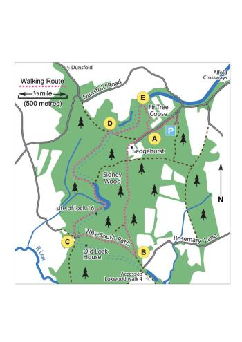
To reach the start of the walk from the A281 at Alfold Crossways, take the secondary road signed to Dunsfold village. After 1 mile the road passes the site where the Wey & Arun Canal Trust is constructing a new bridge under the road to reconnect the Dunsfold and Sidney Wood sections of the canal.
Just past the apex of the bend beyond the works, turn left down an unmarked track. Two left forks lead to a height barrier and a Forestry Commission car park in Sidney Wood. Start the walk by walking back up the car park access track and turn left immediately beyond the height barrier onto a straight footpath.
After 300m the path veers right to cross a tarmac road at (A). Follow the bridleway signs forking left after a further 200m – the path narrows initially but after a further 300m and beyond the house on the left, joinsa wide track.
Continue south along the signed bridleway/track. After 600m follow the bridleway sign onto a path forking left into the trees, leading to a T-junction at (B) after a further 300m.
From here there is an option to extend the walk towards Gennets Bridge Lock and Loxwood – turn left and walk 150m southeast through a barrier to the road to join the Loxwood 4 walk (at point D on the Loxwood walk 4 route map - link here).
Otherwise turn right. Here you join the Wey-South Path, a long-distance path that follows the canal route as closely as possible between Guildford and the South Downs Way at Amberley.
Follow the Wey-South path for 700m through a crossroads and a gate. Shortly afterwards, join the tarmac road emerging from the gated access to the Old Lock House. Follow the tarmac for 70m to cross the canal bed, reaching a bridge at (C). Turn sharp right onto the footpath which continues the Wey-South path.
For the next 1.5km the path follows the canal towpath, with the bed of the canal obvious to the right and occasionally in water. Stay on the towpath ignoring a number of access paths, some of which form causeways where the canal has been filled in for access to the far bank.
After 300m is the site of the Sidney Wood lock 16 – identifiable by the rise in the towpath, a causeway across the canal bed and a subsequent widening of the channel where boats could wait. This lock was the southern end of the summit level of the canal and is the only accessible example of the three locks built in Sidney Wood.
After a further 100m the canal meets an existing stream on a bend – the stream has been channelled through a culvert and the base of the canal built above it. The outlet from the culvert can be seen in the woods on the left. A canalside drainage duct shortly thereafter was also part of the water management infrastructure.
800m further on you reach a causeway where the canal bed has been filled in, followed immediately by a rise in the towpath. Now the canal is on an embankment with another culvert far below on the left. There was once a bridge here, highlighting the engineering complexity involved.
Eventually the towpath comes to a T-junction and a gate (D). Here the canal bed disappears into private land. However, it is possible to follow the east side of the canal by turning right to cross the canal, through a gate and immediately left onto a permissive footpath.
The permissive footpath runs through the Fir Tree Copse Nature Reserve which is managed by Surrey Wildlife Trust. Follow the footpath 300m to cross a footbridge and turn left at a junction shortly after. After a further 200m reach a junction at (E). Turn right here - ignore the continuation of the towpath which is a dead-end. The path veers right to avoid a ditch alongside an open field, goes through a gully across a footbridge and up the hill on the other side to meet the public bridleway after 300m at (A). Turn left and cross the tarmac road to retrace your steps to the car park