This walk heads east from Shalford, with some excellent views of the North Downs, before turning south to the original Wey & Arun Canal bridge at Tannery Lane. The route then stays close to the course of the canal before returning to the starting point along the navigable River Wey.
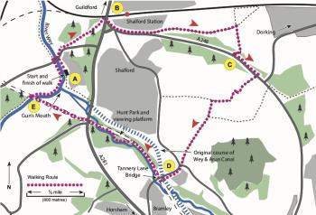
The starting point is the Gunpowder Store at Stonebridge Wharf (A), near the junction of the River Wey and the Wey & Arun Canal. Stonebridge Wharf was an important loading point for river and canal cargo, especially gunpowder from Chilworth (about 2 miles to the east). Nowadays you reach the wharf through Broadford Business Park; the entrance is by the Parrot Inn on Broadford Road (A248).Go through the Business Park entrance, turn right to the river and you will find the Gunpowder Store on your left.
To start the walk, turn right from the Gunpowder Store (assuming you are facing the river) and follow the riverside path to Broadford Road. Carefully cross the road and follow the pavement for about 100 yards to the right. Turn left to head diagonally across Shalford Common to the A281 (B). Cross the main road using the pedestrian crossing by the railway bridge, turn right then bear left to follow Kings Road (A248) past the shops and Post Office. About 100 yards after the Post Office, bear left to follow the path that leads across Station Road and crosses another part of Shalford Common. After about 1⁄2 mile, by Grove Cottage, bear left to follow a minor road across a small stream and past some allotments on the left. When the road turns sharply left, gothrough the gate on the right (do not take the path that goes between two fences), then straight ahead and slightly right across the Guildford Grammar School sports fields to reach another gate in the hedge. Looking to your left, past the pavilion, you will have a good view of St Martha’s Hill and Church. Go through the gate into the grounds of Bradstone Brook (a grand Georgian mansion built in 1791, now converted into a number of large apartments). Bear left to the footbridge and then again slightly left to go through a kissing gate in the fence (C). Continue ahead to follow the A248 pavement to the left. After about 200 yards, carefully cross the road and take the track towards Lower Chinthurst Farm. At the farmhouse gate, turn right and follow the footpath between tall hedges. When the path opens out, turn right and follow it slightly uphill. After about 200 yards, turn left on another path. On this path you will see the wooded Chinthurst Hill ahead and to your left - if you have time and energy it is worth a diversion to discover the round tower at the top. It looks like an ancient ruin but was actually built in the 1930s. When you reach the stile, look right and you may be able to see Guildford and the Cathedral. Turn right at the stile and follow the path downhill to Chinthurst Lane at the entrance to Southland. Cross Chinthurst Lane into Tannery Lane. After about 20 yards, turn left and follow the path leading past the row of houses and across Drodges Lane to Tannery Lane Bridge (D). Turn left then immediately right to cross the original Wey & Arun Canal Bridge built between 1813 and 1816. When the Horsham-Guildford railway was built in the early 1860s, the road level was raised to cross both the canal and the railway. This fortunately preserved the canal bridge intact.
After crossing the canal bridge you are on the course of the railway that closed in 1965. To continue the walk, turn right. (You may wish to make a short diversion and head left for about 200 yards to Gosden Aqueduct where the Wey & Arun Canal Trust has installed an interpretation board.) Follow the course of the old railway (watch out for speeding cyclists) with the Cranleigh Waters river on your left. You are now in the Hunt Nature Park which is being developed by the Wey & Arun Canal Trust. When the river comes close to the old railway, fork left to follow the riverside path that was created by Canal Trust volunteers in 2013. On your right you will see the viewing platform built by the Canal Trust in 2015; the oak trees on the opposite bank of the river are estimated to be more than 500 years old. When the riverside path rejoins the course of the old railway, cross the river and continue straight ahead to the A281 Horsham Road. Carefully cross the road and continue along the route of the old railway to cross a bridge over the River Wey (E).
Immediately after the bridge (installed in 2006), go down the steps to the River Wey towpath. Turn left on the towpath to walk past the The Gun’s Mouth (the start of the Wey & Arun Canal) and the Gunpowder Store. At Broadford Road, carefully cross the bridge to follow the opposite bank back to the Gunpowder Store and the end of the walk.